Before breaking ground, contractors need to answer a critical question: what is buried on the job site?
Utility records, One Call services, electromagnetic locating, ground-penetrating radar (GPR), and physical verification all help contractors identify buried infrastructure before excavation begins. Yet utility strikes remain a persistent problem, in part because records can be incomplete or inaccurate, and what is actually underground does not always match the information available to the contractor.
RodRadar is approaching this problem from a different point in the excavation process. The company’s Live Dig Radar (LDR) technology extends utility detection into active excavation by putting GPR technology directly on the excavator bucket. RodRadar’s LDR Excavate system gives the operator another opportunity to identify buried infrastructure at the start of the digging process and at intervals throughout the excavation.
“The whole industry is focusing on pre-project activities,” says Yuval Barnea, VP of sales and marketing at RodRadar. “We are not saying stop doing all the work that you’re doing,” Barnea says. “You have to, by law, . . . contact 811, use whatever methods that you can to get as accurate information as you can, do surveying before you go on the project site. But everybody knows that it is just not enough.”
Bringing ground-penetrating radar to excavator buckets
Conventional GPR surveys are typically conducted before excavation using an antenna moved across the ground by hand or mounted on a cart or vehicle. The system sends electromagnetic energy into the ground and analyzes the reflected signals to identify subsurface features. RodRadar applies that technology differently with the LDR Excavate bucket and its integrated Live Dig Radar technology.
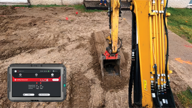
To scan, the operator places the bottom of the bucket against the ground and moves it across the area to be excavated. Reflected radar signals are processed automatically, and audio and visual results appear on the LDR Visualize tablet in the cab within seconds. The display identifies where a potential utility was detected and provides a depth range. The system processes the radar data automatically, eliminating the need for the operator to interpret raw sensor data.
LDR Excavate is designed to scan approximately one metre below the bucket at successive stages of the dig. If the scan confirms that the next layer is clear, the operator can excavate to that depth before scanning again to check for utilities farther below. As the excavator works downward, the radar moves with it, reducing the distance between the sensor and deeper infrastructure.
If an object is detected but is sufficiently far below the bucket, the operator can remove a layer of material, pause excavation, and scan again.
Detection is not limited to a particular utility material. LDR’s algorithms look for the characteristic radar reflections created by buried infrastructure while filtering out other signals, and the system identifies a potential utility without determining exactly what it is.
“It doesn’t matter. We don’t care whether it’s metal [or] plastic because it can be anything,” Barnea says. “It can be a power line conduit, high voltage, low voltage. It can be a plastic conduit with fibre-optics inside. It can be a gas pipeline.”
Accurate detection still depends on proper scanning technique, including sufficient overlap between passes. For the operator, what matters is how close that buried infrastructure is to the next digging pass.
“We call it peeling the onion. Getting closer to the target, and, as [the operator] progresses, getting the information [needed to] avoid the utilities,” Barnea says.
If the detection is close enough that excavation should not continue, the operator stops, and the utility can be exposed using the appropriate method.Before breaking ground, contractors need to answer a critical question: what is buried on the job site?
Utility records, One Call services, electromagnetic locating, ground-penetrating radar (GPR), and physical verification all help contractors identify buried infrastructure before excavation begins. Yet utility strikes remain a persistent problem, in part because records can be incomplete or inaccurate, and what is actually underground does not always match the information available to the contractor.
RodRadar is approaching this problem from a different point in the excavation process. The company’s Live Dig Radar (LDR) technology extends utility detection into active excavation by putting GPR technology directly on the excavator bucket. RodRadar’s LDR Excavate system gives the operator another opportunity to identify buried infrastructure at the start of the digging process and at intervals throughout the excavation.
“The whole industry is focusing on pre-project activities,” says Yuval Barnea, VP of sales and marketing at RodRadar. “We are not saying stop doing all the work that you’re doing,” Barnea says. “You have to, by law, . . . contact 811, use whatever methods that you can to get as accurate information as you can, do surveying before you go on the project site. But everybody knows that it is just not enough.”
Bringing ground-penetrating radar to excavator buckets
Conventional GPR surveys are typically conducted before excavation using an antenna moved across the ground by hand or mounted on a cart or vehicle. The system sends electromagnetic energy into the ground and analyzes the reflected signals to identify subsurface features. RodRadar applies that technology differently with the LDR Excavate bucket and its integrated Live Dig Radar technology.
To scan, the operator places the bottom of the bucket against the ground and moves it across the area to be excavated. Reflected radar signals are processed automatically, and audio and visual results appear on the LDR Visualize tablet in the cab within seconds. The display identifies where a potential utility was detected and provides a depth range. The system processes the radar data automatically, eliminating the need for the operator to interpret raw sensor data.
LDR Excavate is designed to scan approximately one metre below the bucket at successive stages of the dig. If the scan confirms that the next layer is clear, the operator can excavate to that depth before scanning again to check for utilities farther below. As the excavator works downward, the radar moves with it, reducing the distance between the sensor and deeper infrastructure.
If an object is detected but is sufficiently far below the bucket, the operator can remove a layer of material, pause excavation, and scan again.
Detection is not limited to a particular utility material. LDR’s algorithms look for the characteristic radar reflections created by buried infrastructure while filtering out other signals, and the system identifies a potential utility without determining exactly what it is.
“It doesn’t matter. We don’t care whether it’s metal [or] plastic because it can be anything,” Barnea says. “It can be a power line conduit, high voltage, low voltage. It can be a plastic conduit with fibre-optics inside. It can be a gas pipeline.”
Accurate detection still depends on proper scanning technique, including sufficient overlap between passes. For the operator, what matters is how close that buried infrastructure is to the next digging pass.
“We call it peeling the onion. Getting closer to the target, and, as [the operator] progresses, getting the information [needed to] avoid the utilities,” Barnea says.
If the detection is close enough that excavation should not continue, the operator stops, and the utility can be exposed using the appropriate method.
RodRadar brings real-time underground utility detection to excavator buckets
 0 Comments45 Mins Read